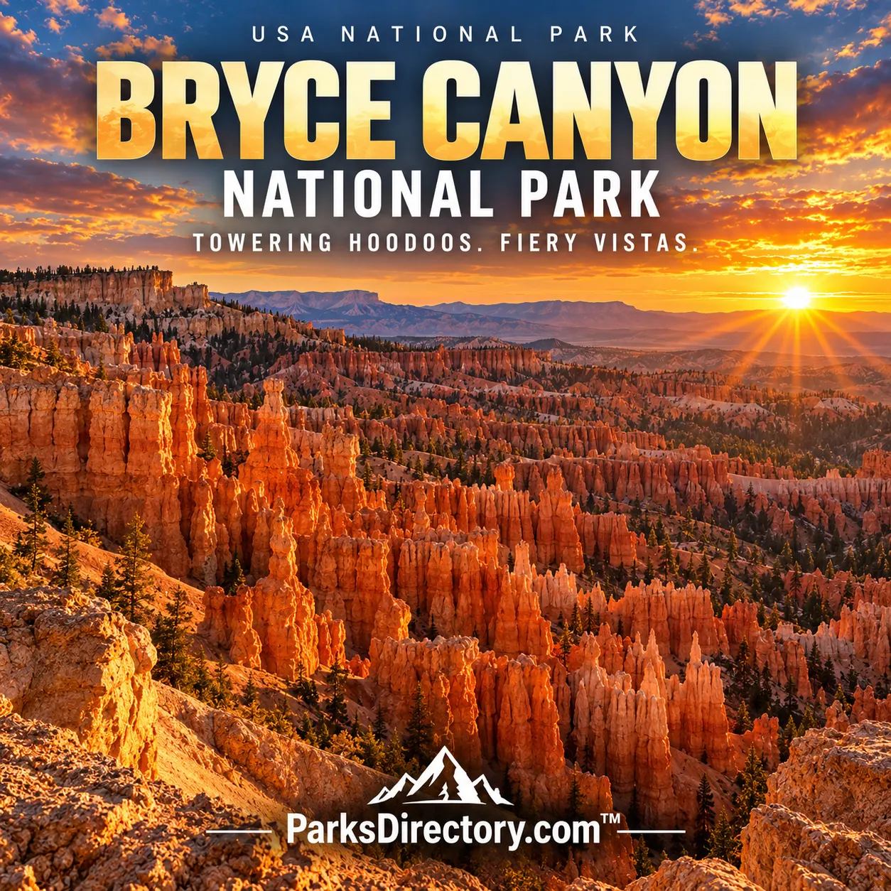
Bryce Canyon National Park

Bryce, Utah · Utah outdoor places

Bryce Canyon National Park

History

Bryce Canyon National Park: Hoodoos, High Plateaus, and a Century of Protection

ParksDirectory.com™ | National Park Summary & History

Location, size, and establishment

Bryce Canyon National Park occupies the eastern edge of the Paunsaugunt Plateau in south-central Utah, near Bryce Canyon City and Tropic. The National Park Service lists 35,835 acres, approximately 56 square miles. Although small beside Utah’s larger desert parks, its elevation and intensely sculpted landscape give it a distinct identity. Rainbow Point reaches 9,115 feet, while lower country descends toward Yellow Creek. This is a high, cold plateau, not simply a hot desert destination.[1]

Its creation involved several legal steps. President Warren Harding proclaimed Bryce Canyon National Monument on June 8, 1923. Congress authorized Utah National Park in 1924 and approved the Bryce Canyon name in February 1928. The NPS statistics chronology identifies September 15, 1928, after required land transfers, as the date the national park was officially established. Earlier authorization and renaming dates should not be confused with that final step.[1:1]

A canyon that is really a series of amphitheaters

The familiar name is somewhat misleading. Rather than a single canyon cut by a major river, Bryce is a succession of amphitheaters eroded into a plateau’s edge. The best-known, Bryce Amphitheater, presents ranks of orange, pink, and pale limestone towers. These towers are hoodoos, the landforms most closely associated with the park. Their abundance, variety, and concentration make Bryce exceptional even within the sandstone country of the Colorado Plateau.[2]

The rocks belong principally to the Claron Formation, deposited in ancient freshwater environments. Their history therefore begins with sediments and water long before the modern spires appeared. Later uplift raised those layers, and weathering attacked exposed weaknesses. The landscape seen from the rim is a surviving fragment of a much larger geologic sequence, not a collection of individually built towers. Knowing that makes the repeated bands and colors easier to read.

Ice and rain at work

Freezing water is one of Bryce’s principal sculptors. Water enters cracks, expands as it freezes, and helps pry rock apart. Rainwater also dissolves calcium-rich material. Over time, broad walls become fins, openings develop into windows, and broken fins leave isolated hoodoos. Harder caps can temporarily shelter softer material below. Eventually the same processes that create a tower destroy it.[2:1]

This explains why winter belongs to the park’s story rather than interrupting it. Snow against red rock is visually striking, but repeated freezing and thawing are also agents of change. Bryce is not a finished sculpture garden. Trails, slopes, and formations occupy an active erosional environment. From a visitor’s perspective, the rim provides the broad pattern, while walking below it reveals fractures, protected ledges, and the surprisingly different proportions of the individual columns.

People before the park

Southern Paiute people have longstanding connections to this plateau country. The human history extends well before nineteenth-century settlement, through generations of travel, hunting, gathering, and knowledge of local resources. A park history centered only on European American arrival would miss that deeper relationship. Indigenous accounts and cultural associations also offer ways of understanding the formations beyond the vocabulary of geology.[3]

Latter-day Saint settlers entered the region during the nineteenth century. Ebenezer and Mary Bryce lived nearby in the 1870s, and the landscape took its English name from the Bryce family. Farming, livestock, timber, and water management shaped settlers’ practical concerns. What visitors later celebrated as spectacular scenery was also demanding country in which to make a living. The name preserves one family’s connection, but it does not mark the beginning of human knowledge of the place.

From local curiosity to national destination

Publicity, local advocacy, and transportation development helped turn Bryce into a nationally recognized destination. Early visitors reached a remote plateau rather than an established resort. As interest grew, conservation and tourism became closely connected: protecting the scenery could also support a regional travel economy. Monument status in 1923 began federal scenic protection under Forest Service administration.[4]

The Utah Parks Company, associated with Union Pacific, developed accommodations and linked Bryce with other southwestern destinations. Architect Gilbert Stanley Underwood designed Bryce Canyon Lodge, and cabins extended the visitor complex. Rail passengers could travel to southern Utah and continue by motor coach. The surviving lodge area makes this period tangible: Bryce’s history includes not only hoodoos and homesteads, but the deliberate creation of a park-tourism landscape. Boundary enlargements in the following decades helped protect more of the plateau edge.[4:1]

The sights that define Bryce

Sunrise Point, Sunset Point, Inspiration Point, and Bryce Point reveal different portions of the main amphitheater. Their names can encourage visitors to think only about the hour of the day, but the essential differences are position, elevation, and perspective. A distant field of towers at one overlook becomes an intricate foreground at another. The Rim Trail provides a connecting introduction to these changing views.[5]

Below the rim, routes such as the Queen’s Garden and Navajo trails enter the formations themselves. Thor’s Hammer is among the best-known individual hoodoos, while the southern scenic drive leads toward Rainbow and Yovimpa points. Those higher overlooks help explain the plateau setting and the wider staircase of southern Utah landscapes. A complete summary of Bryce should include that broader country, not reduce the park to one crowded overlook or one recognizable rock shape.[5:1]

Forests, wildlife, and dark skies

The park’s height supports ponderosa pine, meadows, and higher-elevation fir and spruce communities. These environments contrast with the exposed amphitheaters and provide habitat for a variety of birds and mammals. The transition between forested plateau and eroding slope is part of Bryce’s ecological character. Looking away from the hoodoos reveals a mountain landscape that many first-time visitors do not expect.[3:1]

Dark skies are another important feature. Limited nearby development gives the night sky unusual prominence, while the broad horizon makes the park feel spacious beyond its acreage. Bryce’s lasting appeal comes from these overlapping experiences: delicate-looking rock towers, a working history of settlement and tourism, cold upland forests, and the scale of the surrounding plateau. Federal protection preserved the famous view, but it also secured a place where the forces behind that view remain visible.

Sources

Research checked September 6, 2026. Acreage follows the scope and approximate figures of the cited sources; it is not a current boundary survey. Square-mile conversions are rounded.


  1. National Park Service, Park Statistics. ↩︎ ↩︎

  2. National Park Service, NPS Geodiversity Atlas—Bryce Canyon. ↩︎ ↩︎

  3. National Park Service, History & Culture. ↩︎ ↩︎

  4. National Park Service, Park History. ↩︎ ↩︎

  5. National Park Service, Bryce Canyon National Park. ↩︎ ↩︎

Travel guide

Bryce Canyon National Park: A Travel Guide to Hoodoos and High-Country Views

ParksDirectory.com™ • USA National Parks Travel Guide

Bryce Canyon is a landscape that seems to become more intricate the longer you look. From the rim, rows of orange, pink, and pale rock spires fill a series of natural amphitheaters. A trail below the edge changes the perspective completely, placing those formations beside you rather than beneath you. This southern Utah park rewards both travelers who prefer overlooks and hikers willing to climb back out of its high-elevation terrain.[1]

The most useful first-visit strategy is simple: concentrate on the main Bryce Amphitheater before adding distant viewpoints. Give yourself time to understand the hoodoos, choose a walk that fits your ability, and remember that the easy-looking descent is only half the journey.

Begin with the amphitheater

The National Park Service recommends the main amphitheater area as the focus for a first visit. Much of the park’s signature scenery and many day-hike trailheads are concentrated near the first part of the main road, while farther backcountry routes emphasize forests, meadows, and more distant cliff views.[1:1]

Start at a rim viewpoint and study the way separate towers form ridges and corridors. Notice the trees growing among the rock and the contrast between sunlit faces and shaded recesses. This is a good place to decide whether the day calls for a below-rim hike or a gentler sequence of viewpoints. Either can provide a complete experience. The mistake is choosing a strenuous walk only because it appears to be the standard thing to do.

Connect Sunrise and Sunset points

Sunrise Point and Sunset Point are useful anchors for exploring the amphitheater. The paved portion of Rim Trail between them provides a relatively gentle way to compare views, and both are associated with access to the popular Queen’s Garden and Navajo trail combination.[1:2][2]

Their names should not dictate your entire schedule. A viewpoint can be rewarding at many times, depending on light and weather. Walk slowly, look back occasionally, and allow the angle of the formations to change. Visitors with mobility needs should check current accessibility details and surface conditions rather than assuming that a paved route is equally comfortable in every season. Ice, snow, crowds, and the approach from parking can all affect the practical experience of a short walk.

Choose a below-rim hike carefully

The Queen’s Garden and Navajo combination is a celebrated way to enter the hoodoo landscape. Official guidance recommends a clockwise approach, descending Queen’s Garden and returning by an available side of Navajo Loop, with the rim connection completing the outing.[2:1]

Before starting, check which sections are open and assess the climb back to the rim. Do not confuse a familiar route name with a guarantee of suitable conditions. Carry water, food, and a layer, and allow time for pauses without pushing the return into an uncomfortable rush. Travelers uneasy with steep grades or exposure can enjoy the amphitheater from above instead. A shorter walk chosen well is better than completing a famous loop while exhausted or anxious.

Look beyond the first cluster of viewpoints

Bryce’s southern high country offers a broader sense of the plateau, with long views beyond the park’s most concentrated hoodoo scenery. The official park overview distinguishes these higher viewpoints and backcountry landscapes from the main amphitheater.[3]

Once you have spent time near the rim, consider a scenic-drive extension rather than another demanding hike. Use it to notice changes in forest, elevation, and the shape of the horizon. Avoid making every pullout mandatory. Choose stops where the weather and visibility are favorable, and keep enough time for the drive back. Travelers especially interested in walking should compare the park’s trail descriptions carefully: a forest-focused route offers a different experience from a hoodoo-focused route, even when both are equally worthwhile.

Respect the altitude and weather

Bryce Canyon is a high-elevation park, and the National Park Service cautions that its trails can feel more demanding than visitors expect. Winter adds a particular challenge: popular routes and even developed surfaces can become icy, making suitable traction important.[1:3][4]

Arrive with a flexible plan for the first day. Walk at a comfortable pace, pause before fatigue becomes a problem, and do not judge your performance against someone else’s. Pack layers that allow for changing conditions rather than relying on the temperature at a nearby lower-elevation destination. In winter, check the current route guidance and use equipment appropriate to the surface. Turning around because a trail is icy is a sound decision, not a missed opportunity that needs to be corrected.

Make practical arrangements before arrival

The park’s planning pages cover entrance information, permits, camping, and seasonal transportation. Shuttle arrangements and operating dates should be checked for the specific visit rather than assumed from a previous year.[3:1][5]

Choose accommodation that supports an early, relaxed start, especially if you hope to walk below the rim. Campers should distinguish the park’s developed campgrounds from backcountry camping, which requires a different level of preparation. Carry lunch and water so that the day does not revolve around finding a meal between activities. Review parking and vehicle-size guidance before driving to the busiest area. For a family or group, agree on a modest primary plan and an optional extension instead of creating an itinerary that requires everyone to keep the same pace all day.

Leave time for the night sky

Stargazing is among the activities highlighted by the park. A Bryce visit can therefore extend beyond its daytime rock scenery without adding another long drive or strenuous trail.[6]

For an evening outdoors, select an appropriate developed location and prepare for cold. Bring a light for moving safely, keep its use considerate around others, and know the route back before darkness falls. A ranger program, when available, can add context that a casual look at the sky may miss. Do not make staying out late a requirement after an exhausting hiking day. The best evening is one you can enjoy attentively, with enough energy for safe travel afterward and without sacrificing the following morning’s plans.

A suggested two-day introduction

On the first day, begin with visitor information, explore the rim between selected viewpoints, and choose one manageable walk. Spend the afternoon comparing light across the amphitheater rather than immediately driving onward to another park.

Use the second day for a suitable below-rim hike or a scenic-drive extension into the higher southern area. Leave time for rest and, if conditions cooperate, an evening sky experience. This is an editorial framework; trail status and weather should decide the final order.

Stay on established routes, leave rock and vegetation untouched, and avoid crowding narrow viewpoints. Bryce Canyon does not need to be hurried. Its richest impression comes when the formations stop looking like one orange mass and begin to resolve into individual towers, windows, trees, and passages shaped by time.

Sources

Prepared September 6, 2026. Suggested itineraries are editorial recommendations. Check official park alerts, reservations, and operating information before traveling.


  1. National Park Service, Hiking. ↩︎ ↩︎ ↩︎ ↩︎

  2. National Park Service, Queen’s Garden and Navajo Combination. ↩︎ ↩︎

  3. National Park Service, Bryce Canyon National Park. ↩︎ ↩︎

  4. National Park Service, Visiting in Winter. ↩︎

  5. National Park Service, Plan Your Visit. ↩︎

  6. National Park Service, Things to Do. ↩︎